 ar
ar bg
bg hr
hr cs
cs da
da nl
nl fi
fi fr
fr de
de el
el hi
hi it
it ko
ko no
no pl
pl pt
pt ro
ro ru
ru es
es sv
sv tl
tl iw
iw id
id lv
lv lt
lt sr
sr sk
sk sl
sl uk
uk vi
vi et
et hu
hu th
th tr
tr fa
fa ms
ms hy
hy ka
ka ur
ur bn
bn mn
mn ta
ta kk
kk uz
uz ku
ku
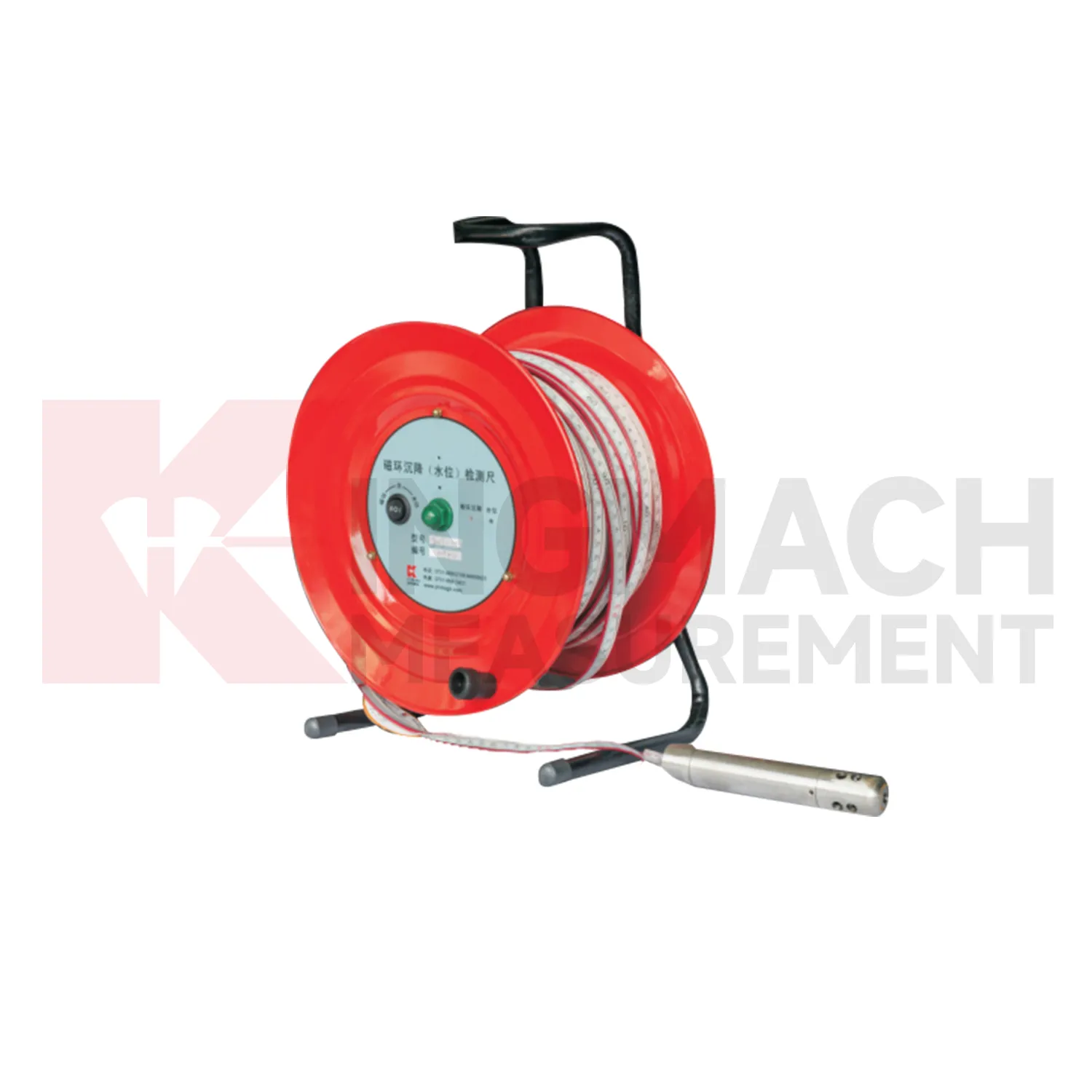
Magnetic Ring Settlement Water Level Gauge
Kingmach Magnetic Ring Settlement Water Level Gauge should be selected from the engineering question outward. If the question is pile foundation settlement or tunnel bottom uplift, an embedded single-point gauge such as JMDL-47XXAT may fit the job. If the question is bridge deflection or building settlement across several points, hydrostatic instruments such as JMDL-62XXADT or JMQJ-62XXADT can compare vertical change against a reference. If the question is large settlement during soft foundation treatment or reclamation filling, JMYC-62XXAD provides wider travel from 500 mm to 4000 mm. If the question involves layered soil settlement and groundwater level, JMCJ-1003/1005 gives a borehole-based manual method. A good specification therefore starts with movement scale, reading frequency, access, groundwater condition, reference stability, and report needs. During procurement review, engineers should check range, resolution, accuracy, output signal, installation method, and maintenance access together rather than selecting from model names alone. The acceptance record should keep model, range, reference relationship, baseline, installation detail, and channel name together for later review. The acceptance record should keep model, range, reference relationship, baseline, installation detail, and channel name together for later review. The acceptance record should keep model, range, reference relationship, baseline, installation detail, and channel name together for later review. The acceptance record should keep model, range, reference relationship, baseline, installation detail, and channel name together for later review.
Application of Magnetic Ring Settlement Water Level Gauge
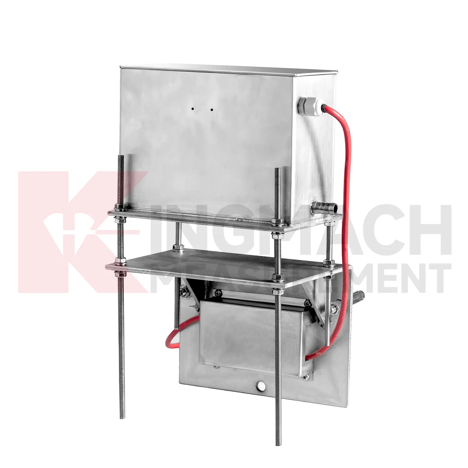
In dam monitoring, Magnetic Ring Settlement Water Level Gauge are used for long-term observation of dam body settlement, gallery deformation, foundation movement, and vertical change near water-control structures. This work has a slow rhythm: reservoir level, seepage, rainfall, seasonal temperature, and consolidation history may all affect the curve. Kingmach JMQJ-62XXADT gives micro range hydrostatic measurement with IP68 protection and 0.01 mm resolution, while JMYC-62XXAD provides wider 500 mm to 4000 mm ranges for larger vertical displacement. JMDL-62XXADT can form a multi-point hydrostatic leveling network when several positions must be compared from one reference. A dam layout should treat the reference location, tube route, cabinet position, cable protection, and access path as part of the measurement system. During operation, engineers should review settlement data with reservoir records, seepage flow, piezometer behavior, inspection notes from galleries, and downstream observation results. The goal is to see whether a slow trend matches expected consolidation or whether it appears near a structural joint, foundation zone, or water level event. Good records make annual dam-safety review more traceable and reduce confusion when readings are checked years later.
The future of Magnetic Ring Settlement Water Level Gauge
Asset management will be a stronger future use for Magnetic Ring Settlement Water Level Gauge. Owners of railways, highways, bridges, dams, and buildings need to know which sections are stable, which sections are still consolidating, and which points need maintenance budget. Settlement data can support that ranking when it is collected consistently over years. Kingmach products such as JMDL-47XXAT, JMQJ-62XXADT, JMDL-62XXADT, JMYC-62XXAD, and JMCJ-1003/1005 give different ways to measure vertical movement and groundwater conditions. Future asset systems can connect those records to inspection cycles, repair history, risk level, and renewal planning. The result is a settlement record that supports long-term decisions, not only construction-stage alarms. A mature asset file should show which points are healthy, which require field checking, and which have reached the end of useful instrument life.
Care & Maintenance of Magnetic Ring Settlement Water Level Gauge
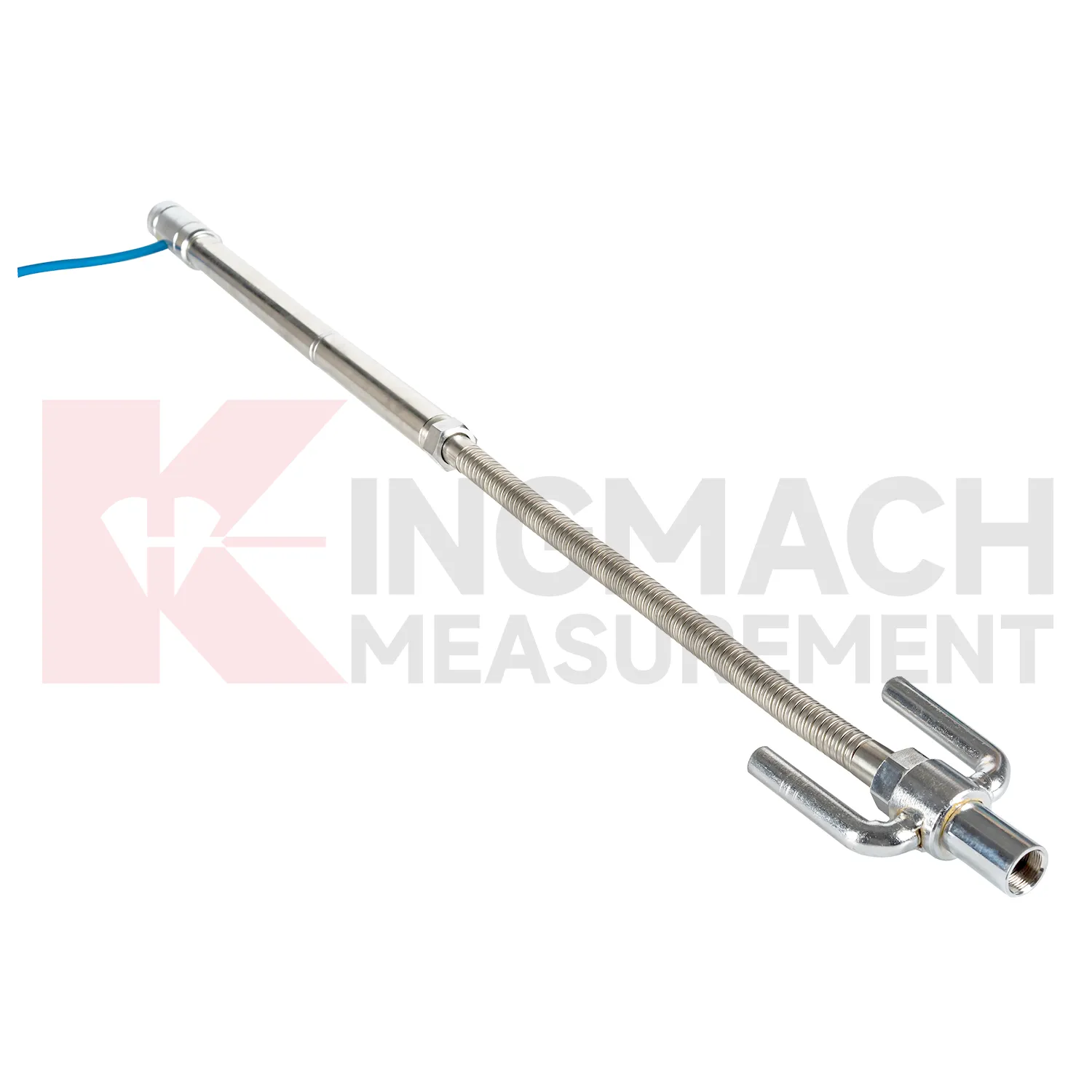
Embedded Magnetic Ring Settlement Water Level Gauge such as JMDL-47XXAT require protection during earthwork, paving, and later traffic. The settlement plate, measuring rod, metal flexible conduit, anchor head, extension rod, bottom anchor, and side-exit cable should be installed without being bent or crushed by compaction equipment. Record installation depth, gauge length, cable exit point, fill layer, protection cover, and first stable reading before the point is buried. During maintenance, inspect accessible cable sections, junction boxes, cabinet terminals, and any area where later excavation may have disturbed the line. If a curve changes after a filling stage or pavement operation, compare the timing with construction logs before judging the ground response. Buried parts are difficult to inspect after coverage, so photographs, as-built sketches, and cable route notes become part of the working instrument. Good embedded-point care is mostly quiet prevention done before damage becomes visible.
Kingmach Magnetic Ring Settlement Water Level Gauge
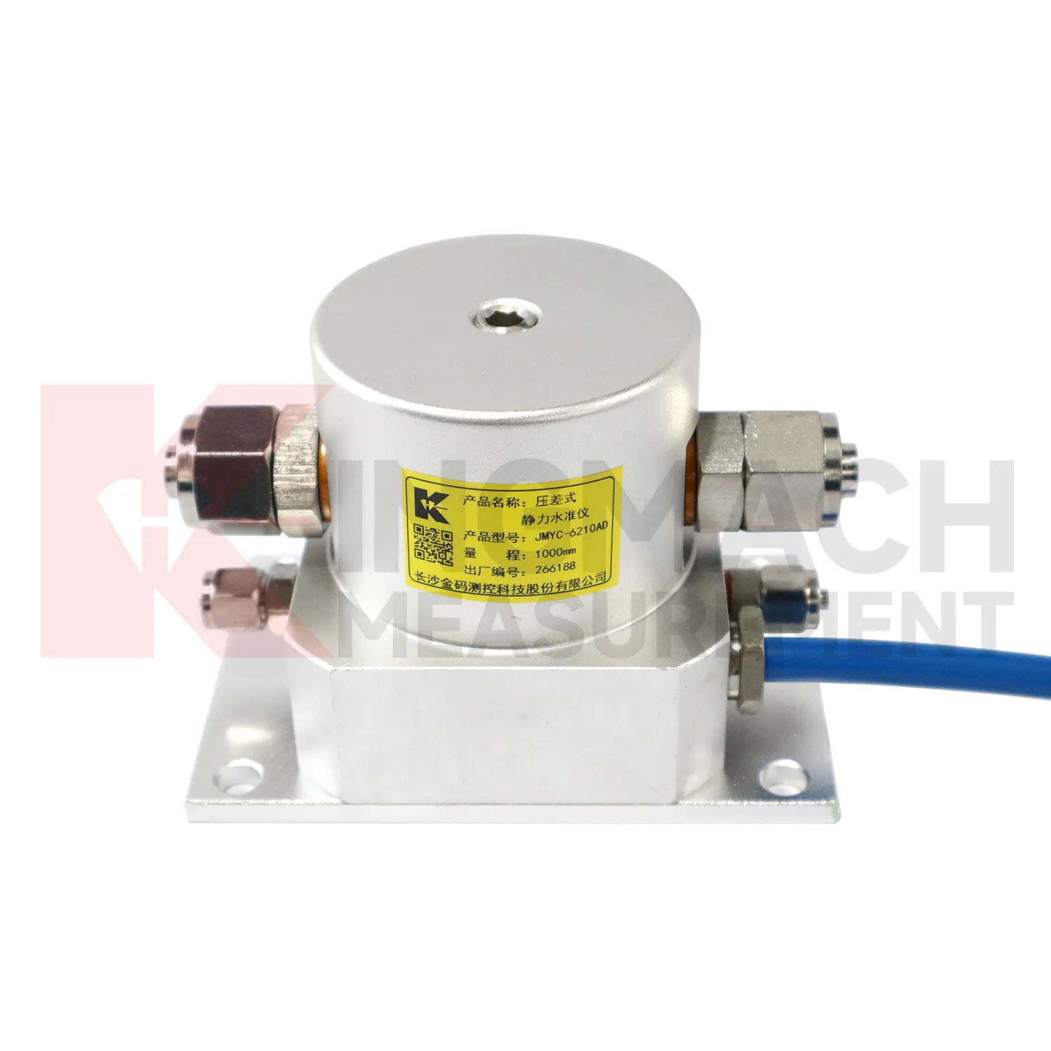
Wide-area settlement monitoring needs Magnetic Ring Settlement Water Level Gauge that can handle larger travel and uneven profiles. Kingmach JMYC-62XXAD wide-range differential pressure hydrostatic level sensors are designed for pavement settlement, cross-sectional nonlinear settlement, soft foundation treatment, land reclamation foundations, dam subgrades, slope stability, bridge deflection, and building settlement. The listed range extends from 500 mm to 4000 mm, with 0.1 mm resolution and 0.2%FS accuracy. This makes it different from micro range sensors used for smaller deflection changes. A long road or reclamation section should not be judged by one point only. The value comes from comparing a profile over time, then linking that profile with filling stage, surcharge timing, drainage records, groundwater, and site inspection notes. This is especially important when several instruments share one cabinet or when hydrostatic tubes, embedded rods, and manual borehole readings appear in the same project. This is especially important when several instruments share one cabinet or when hydrostatic tubes, embedded rods, and manual borehole readings appear in the same project.
FAQ
Q: Which Magnetic Ring Settlement Water Level Gauge fit hydrostatic leveling?
A: JMDL-62XXADT, JMQJ-62XXADT, and JMYC-62XXAD are used for hydrostatic or differential pressure settlement monitoring.
Q: What resolution is available?
A: JMDL-62XXADT and JMQJ-62XXADT list 0.01 mm resolution, while JMYC-62XXAD lists 0.1 mm resolution for wider ranges.
Q: Where are micro range hydrostatic sensors used?
A: They are used for dam settlement, bridge deflection, slope stability, building settlement, tunnel settlement, and subgrade settlement.
Q: What protection rating is listed for JMQJ-62XXADT?
A: The product information lists IP68 protection.
Q: What can damage hydrostatic readings?
A: Leaking tubes, air pockets, poor reference control, temperature effects, cable faults, and disturbed sensor elevations can all affect the record.
Reviews
Christopher Martinez
Very satisfied with the readouts & data loggers. User-friendly interface and supports multiple sensor inputs.
Joshua Clark
We ordered a full monitoring solution including sensors and data loggers. Everything works seamlessly together. Great supplier!
Latest Inquiries
To protect the privacy of our buyers, only public service email domains like Gmail, Yahoo, and MSN will be displayed. Additionally, only a limited portion of the inquiry content will be shown.
Harper***@gmail.comIndia
Dear Sir, we are planning to procure a complete monitoring system including strain gauges, tiltmeter...
Amelia***@gmail.comSingapore
Hello, I am looking for visualization software for monitoring system data analysis. Please let me kn...
Related product categories
- Micro Range Hydrostatic Level Sensor
- Single-point Settlement Meter
- Optical Deflection Monitor
- Inclinometer-based Hydrostatic Leveling System
- Settlement Monitoring Rod
- Hydrostatic Leveling System
- Photoelectric Deflectometer
- gnss settlement sensors
- settlement sensor
- settlement sensors
- rod settlement gauge
- settlement gauge